IOER Monitor
"How do humans affect natural areas, for example through new settlement areas? Where are soils sealed – and since when? Knowing how land use changes in Germany is an important basis for biodiversity research. We would like to contribute this data via the integration of the IÖR monitor into NFDI4Biodiversity."
Gotthard Meinel, Head of Research Area Spatial Information and Modelling at the Leibniz Institute of Ecological Urban and Regional Development (IÖR)
About the Leibniz Institute of Ecological Urban and Regional Development (IÖR)
The IÖR develops scientific foundations, analytical tools and instruments for the sustainable development and transformation of regions, cities and neighborhoods. Among other things, its research contributes to the development of landscapes and settlement areas in harmony with the natural foundations of life. With its monitor of settlement and open space development (IÖR monitor), IÖR contributes data and indicators on land use, land cover and landscape change to the NFDI4Biodiversity consortium. This information allows conclusions to be drawn about the development of ecosystems and forms an important basis for the protection of habitats and biodiversity.
How we work together
With the community for the community: The NFDI4Biodiversity Use Case Model
As a biodiversity and environmental data consortium, we work to make valuable knowledge sustainably available - and to find solutions that are really needed. Around 20 use cases from the biodiversity community - the NFDI4Biodiversity Use Cases - help us to explore needs, identify challenges and work together to break new ground: towards data that is findable, accessible, interoperable, and reusable (see FAIR principles). One of them is the IÖR monitor, whose data will be integrated into NFDI4Biodiversity.
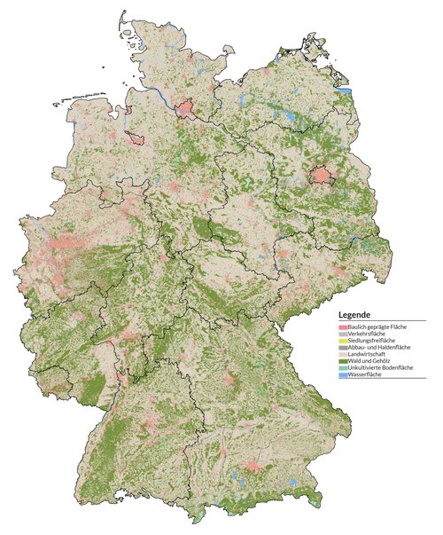
The data
The IÖR monitor is based on the combined processing of official geobasis, geospecialist and statistical data (re3data repository of the IÖR). From these, 88 so-called indicators are derived, which in turn are subdivided into 14 thematic categories, including for example settlement, open space or transport. In a map viewer, land use, land cover and landscape quality as well as their changes can be displayed spatially, temporally and thematically in high resolution for Germany. The time series start in the year 2000 and have been updated annually since 2008. In addition, IÖR researchers are working on retrospectively completing them for the period before 2000 as well. The IÖR monitor data differentiates 39 land use types and is available in raster resolutions from 100 meters to 10 kilometers or in vector format for a number of structural units - such as federal states, municipalities or spatial planning regions. Among other things, the data are the basis for the description of ecosystem states and the assessment of ecosystem services.
The common goal
The goal is to integrate the IÖR monitor data into NFDI4Biodiversity. "Land use changes are a basis for biodiversity, climate, sustainability and Earth system research," said Gotthard Meinel, Head of Research Area Spatial Information and Modelling at the IÖR, about his motivation to collaborate in NFDI4Biodiversity. Other biodiversity data, for example on the occurrence of animal and plant species, could thus be linked with data on soil types, sealing or settlement of land areas and put into perspective over different time spans in order to gain new insights. In addition, the IÖR would like to make its data offering better known and is interested in feedback on the functionalities of the IÖR monitor.
The current status
To enable the integration of the data, they were extracted from the IÖR Monitor in a first step. Subsequently, they are to be stored in CORE storage - the distributed storage system being set up in the National Research Data Infrastructure (NFDI). This is already working in test mode. Work is currently underway to enrich the metadata of the integrated datasets to make them easier to combine with other data sources. The work so far illustrates one of the major challenges in NFDI4Biodiversity: for data to be brought from one infrastructure to another, a lot of preparatory work is needed, for example in the area of data transformation and NFDI infrastructure construction. In the case of the IÖR monitor, the foundation has been laid here.
Contact person
Leibniz Institute of Ecological Urban and Regional Development (Leibniz-Institut für ökologische Raumentwicklung, IÖR)
Gotthard Meinel (G.Meinel@ioer.de), Head of Research Area Spatial Information and Modelling
www.ioer.de
www.ioer-monitor.de
NFDI4Biodiversity
If you have any questions about the IÖR Monitor use case or NFDI4Biodiversity in general, please contact us using our contact form.
Discover other use cases
Learn more about the other natural history societies, museums, government agencies, and research institutions and projects with which we collaborate.
Gesellschaft für Ichthyologie e.V. (GfI)
Die Fischkundler:innen der GfI verfügen über mehr als 100.000 Datensätze zur Verbreitung aller regionalen Arten. Gemeinsam arbeiten wir daran, dieses wertvolle Wissen leichter zugänglich zu machen – damit es u.a. dem Schutz der Fischfauna zugute kommen kann.
Gesellschaft deutschsprachiger Odonatologen e.V. (GdO)
Rund zwei Millionen Libellendaten, die auch Forschung und Naturschutz zur Verfügung stehen sollen – daran arbeiten wir mit den Libellenkundler:innen der GdO.
Übersicht aller Use Cases
Hier geht es zu allen NFDI4Biodiversity-Use-Cases im Überblick.